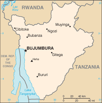

BURUNDI
|
Location:
|
Central Africa, east of Democratic Republic of the Congo |
|
Geographic coordinates:
|
3 30 S, 30 00 E |
|
Map references:
|
Africa |
|
Area:
|
total: 27,830 sq km land: 25,650 sq km water: 2,180 sq km |
|
Climate:
|
Equatorial; high plateau with considerable altitude variation (772 m to 2,670 m above sea level); average annual temperature varies with altitude from 23 to 17 degrees centigrade but is generally moderate as the average altitude is about 1,700 m; average annual rainfall is about 150 cm; wet seasons from February to May and September to November, and dry seasons from June to August and December to January |
|
Terrain:
|
Hilly and mountainous, dropping to a plateau in east, some plains |
|
Elevation extremes:
|
lowest point: Lake
Tanganyika 772 m highest point: Mount Heha 2,670 m |
|
Natural resources:
|
Nickel, uranium, rare earth oxides, peat, cobalt, copper, platinum (not yet exploited), vanadium, arable land, hydropower |
|
Land use:
|
arable land: 35.05% permanent crops: 14.02% other: 50.93% (2001) |
|
Irrigated land:
|
740 sq km (1998 est.) |
|
Natural hazards:
|
flooding, landslides, drought |
|
Environment Main
|
Main problem is soil erosion as a result of overgrazing and the expansion of agriculture into marginal lands. Deforestation (Trees used for fule the main problem here), and habitat loss threatens wildlife populations |
|
Population:
|
6,231,221 note: estimates for this country explicitly take into account the effects of excess mortality due to AIDS; this can result in lower life expectancy, higher infant mortality and death rates, lower population and growth rates, and changes in the distribution of population by age and sex than would otherwise be expected (July 2004 est.) |
|
Age structure:
|
0-14 years: 46.4%
(male 1,459,251; female 1,430,332) 15-64 years: 50.9% (male 1,566,274; female 1,607,705) 65 years and over: 2.7% (male 66,306; female 101,353) (2004 est.) |
|
Median age:
|
total: 16.5 years male: 16.1 years female: 16.8 years (2004 est.) |
|
Population growth rate:
|
2.2% (2004 est.) |
|
Birth rate:
|
39.68 births/1,000 population (2004 est.) |
|
Death rate:
|
17.61 deaths/1,000 population (2004 est.) |
|
Net migration rate:
|
-0.06 migrant(s)/1,000 population (2004 est.) |
|
Sex ratio:
|
at birth: 1.03 male(s)/female under 15 years: 1.02 male(s)/female 15-64 years: 0.97 male(s)/female 65 years and over: 0.65 male(s)/female total population: 0.99 male(s)/female (2004 est.) |
|
Infant mortality rate:
|
total: 70.4
deaths/1,000 live births male: 77.15 deaths/1,000 live births female: 63.45 deaths/1,000 live births (2004 est.) |
|
Life expectancy at birth:
|
total population:
43.36 years male: 42.73 years female: 44 years (2004 est.) |
|
Total fertility rate:
|
5.9 children born/woman (2004 est.) |
|
HIV/AIDS - adult prevalence rate:
|
6% (2003 est.) |
|
HIV/AIDS - people living with HIV/AIDS:
|
250,000 (2003 est.) |
|
HIV/AIDS - deaths:
|
25,000 (2003 est.) |
|
Nationality:
|
noun: Burundian(s) adjective: Burundian |
|
Ethnic groups:
|
Hutu (Bantu) 85%, Tutsi (Hamitic) 14%, Twa (Pygmy) 1%, Europeans 3,000, South Asians 2,000 |
|
Religions:
|
Christian 67% (Roman Catholic 62%, Protestant 5%), indigenous beliefs 23%, Muslim 10% |
|
Languages:
|
Kirundi (official), French (official), Swahili (along Lake Tanganyika and in the Bujumbura area) |
|
Literacy:
|
definition: age 15 and
over can read and write total population: 51.6% male: 58.5% female: 45.2% (2003 est.) |
|
Telephones - main lines in use:
|
23,900 (2003) |
|
Telephones - mobile cellular:
|
64,000 (2003) |
|
Telephone system:
|
general assessment:
primitive system domestic: sparse system of open-wire, radiotelephone communications, and low-capacity microwave radio relay international: country code - 257; satellite earth station - 1 Intelsat (Indian Ocean) |
|
Radio broadcast stations:
|
AM 0, FM 4, shortwave 1 (2001) |
|
Television broadcast stations:
|
1 (2001) |
|
Internet country code:
|
.bi |
|
Internet hosts:
|
22 (2003) |
|
Internet users:
|
14,000 (2003) |
|
Highways:
|
total: 14,480 km paved: 1,028 km unpaved: 13,452 km (1999 est.) |
|
Waterways:
|
mainly on Lake Tanganyika (2004) |
|
Ports and harbors:
|
Bujumbura |
|
Airports:
|
8 (2003 est.) |
|
Airports - with paved runways:
|
total: 1 over 3,047 m: 1 (2004 est.) |
|
Airports - with unpaved runways:
|
total: 7 914 to 1,523 m: 4 under 914 m: 3 (2004 est.) |